


Apr 12, 2016

Western Europe by Stuart Rankin Via Flickr: Edited MODIS Aqua image of Western Europe.

seen from United States

seen from United States

seen from Malaysia

seen from Malaysia

seen from Mexico

seen from United States
seen from China
seen from Indonesia

seen from France

seen from Indonesia

seen from United States

seen from Canada
seen from United States

seen from Türkiye

seen from United States

seen from Indonesia

seen from United States
seen from Indonesia

seen from India

seen from United States
Western Europe by Stuart Rankin Via Flickr: Edited MODIS Aqua image of Western Europe.
Washington/British Columbia Region of North America by Stuart Rankin Via Flickr: Edited Suomi NPP image of the Pacific North West (if you're in the US, Pacific South West if you're in Canada) from over the Gulf of Alaska.

Busy Eastern Pacific Ocean by Stuart Rankin Via Flickr: Edited Suomi NPP image of the Eastern Pacific Ocean and phytoplankton and eddies and swirls off the coast of California.
California Obliquely by Stuart Rankin Via Flickr: Edited NASA oblique image of California and forest fires.
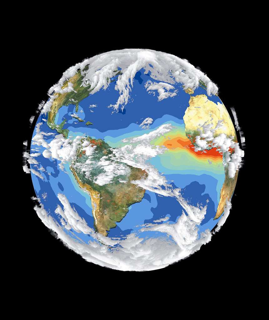
Satellite Image of Earth's Interrelated Systems and Climate by NASA on The Commons Via Flickr: Satellite data and images such as those presented in this image of Earth give scientists a more comprehensive view of the Earth's interrelated systems and climate. Four different satellites contributed to the making of this image. Sea-viewing Wide Field-of-view Sensor (SeaWiFS) provided the land image layer and is a true color composite of land vegetation for cloud-free conditions from September 18 to October 3, 1997. Each red dot over South America and Africa represents a fire detected by the Advanced Very High Resolution Radiometer. The oceanic aerosol layer is based on National Oceanic and Atmospheric Administration (NOAA) data and is caused by biomass burning and windblown dust over Africa. The cloud layer is a composite of infrared images from four geostationary weather satellites, NOAA's GOES 8 and 9, the European Space Agency's METEOSAT, and Japan's GMS 5. Image # : 119 Date: September 18, 1997